

Beyond the Story: Isolating Spatial and Hydrological Signals at Yabboq
Research Arc I: Land, Authority, and Memory in the Ancient Near East

Welcome back to The Land Beneath the Story, my ongoing investigation into terrain, hydrology, movement corridors, and the remembered landscapes of the Torah and Qur’an.
Today’s installment marks a turning point.
Until now, much of this project has asked what the texts suggest about landscape. This stage asks what happens when the landscape is allowed to answer back.
This is the first empirical test of whether part of a sacred narrative’s geography can be evaluated independently of the story itself.
Uncovering the Landscape Beneath the Jacob Narrative
Most discussions of sacred geography begin with the story.
A journey is remembered.
A crossing is narrated.
A well, valley, mountain, or boundary becomes important because the text tells us that something happened there.
But that creates a methodological problem.
If I already know where the story says to look, how do I keep myself from finding significance simply because I went looking for it?
That question has increasingly become central to my research.
The prophets did not move through empty space. They moved through terrain shaped by water, elevation, passes, basins, settlement possibilities, and political boundaries.
If those physical constraints matter historically, they should be detectable without first assuming that the narrative is correct.
GIS changes the problem.
Instead of asking whether a landscape can be made to fit a remembered journey, we can ask whether the landscape produces structure independently.
This is my first attempt to do exactly that.
The Yabboq as an Experiment
I began with the Yabboq, the Wadi Zarqa basin in Jordan.
The choice was not an attempt to identify Jacob’s route or validate a textual event. I needed a bounded landscape in which the hydrological component of a larger hypothesis could be isolated and tested.
The question was deliberately narrow:
If drainage is derived from terrain alone, before any mapped waterways are introduced, does the resulting network correspond to independently mapped hydrography more strongly than we would expect by chance or from similar terrain conditions?
Notice what this question does not ask.
It does not ask whether Jacob crossed at a particular point.
It does not ask whether the narrative can be historically verified by terrain alone.
It asks whether the landscape contains a recoverable spatial signal before historical interpretation enters the model.
Terrain as Data
Using NASA/USGS SRTM 1-arcsecond elevation data, I converted the basin into an analytical terrain model.
The elevation tiles were merged, clipped to the study area, and projected into UTM Zone 36N so distances could be measured consistently in meters.
From that terrain I derived slope and ruggedness, calculated D8 flow direction, and accumulated upstream flow across the raster.
The idea is straightforward even if the machinery sounds technical:
water follows terrain.
If enough upstream cells converge on the same downslope path, that path begins to behave like a potential drainage corridor.
I therefore extracted drainage at three accumulation thresholds:
250 contributing cells
500 contributing cells
1000 contributing cells
Lower thresholds produce denser networks. Higher thresholds isolate progressively stronger terrain-defined channels.
Crucially, the mapped waterways were still absent.
The terrain had to make its prediction first.
The Harder Question: Could the Result Happen Anyway?
Finding apparent agreement would not be enough.
Valleys tend to occur in valley-like terrain. Drainage tends to occupy lower, steeper, or otherwise distinctive parts of a landscape. A model could therefore appear successful while doing nothing more impressive than rediscovering generic terrain structure.
So I built two ways for the result to fail.
1. Density-matched random-cell null
The same number of raster cells as the derived drainage network were placed randomly within the valid study area.
2. Terrain-matched null
Control cells were selected from approximately similar combinations of:
elevation
slope
terrain ruggedness
The comparison was therefore no longer simply:
drainage versus randomness
but:
drainage versus other places that look broadly like drainage terrain.
Neither control was allowed to use the reference hydrography.
I also avoided selecting one convenient matching distance. Agreement was tested at:
30 m, 60 m, 90 m, 150 m, and 300 m.
That forced the result to survive across multiple spatial tolerances rather than one favorable setting.
The First Result
The 1000-cell network provides the clearest first illustration because it is the sparsest of the three derived networks and emphasizes the strongest terrain-defined channels.
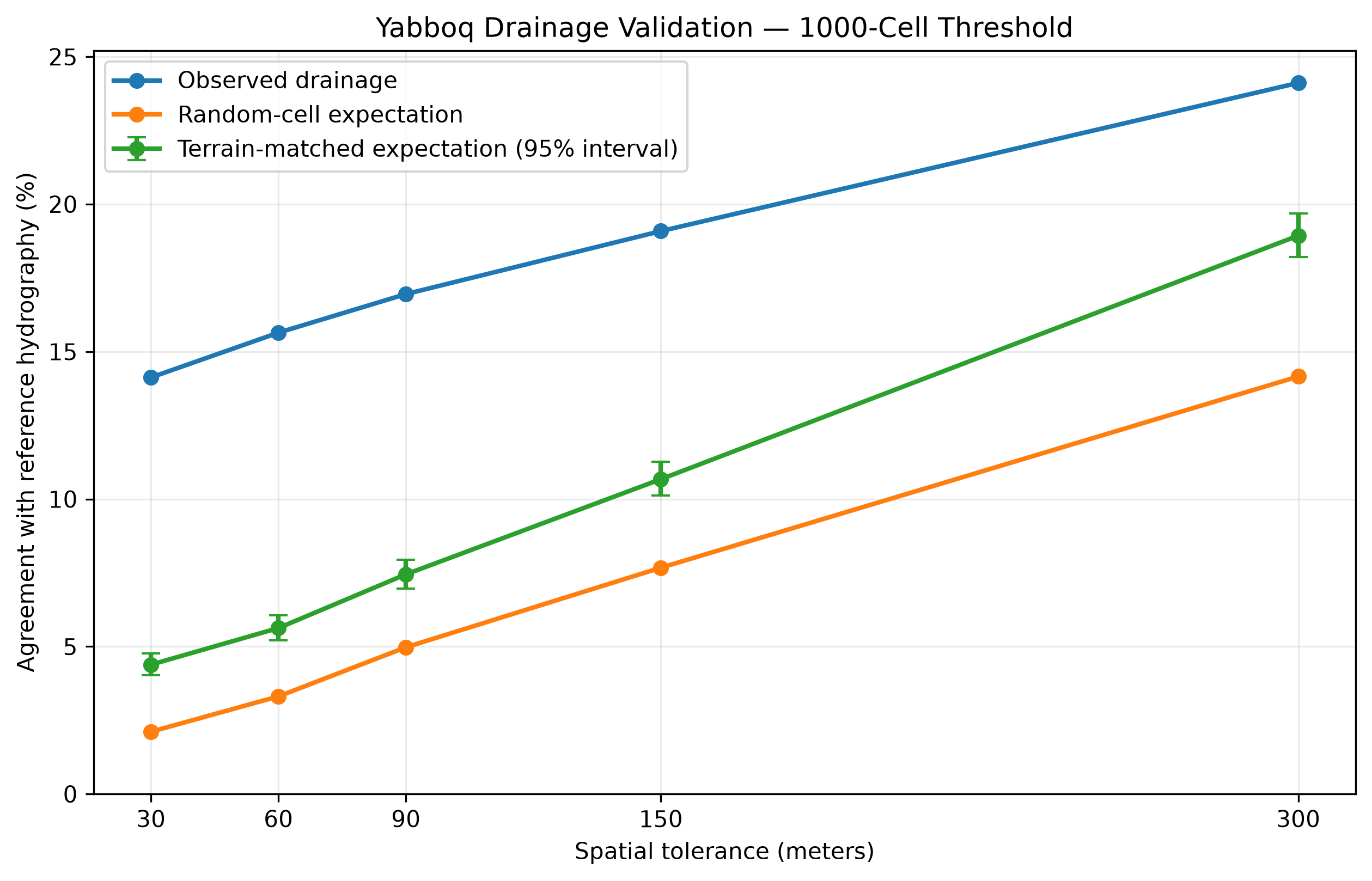
Terrain-derived drainage at the 1000-cell threshold shows greater agreement with independently mapped hydrography than either random-cell or terrain-matched expectations across every tested spatial tolerance. This comparison evaluates spatial correspondence only and does not identify an ancient route.
Across every tested tolerance, the observed drainage network remained above both control expectations.
Against the stronger terrain-matched control, the separation was approximately:
+9.74 percentage points at 30 m
+10.02 at 60 m
+9.50 at 90 m
+8.41 at 150 m
+5.18 at 300 m
The same general pattern appeared at the 250- and 500-cell thresholds, although the magnitude changed as network density changed.
The complete tables and comparison outputs are available on GitHub for readers who want to inspect the full results.
What This Does Not Mean
This result does not identify Jacob’s crossing.
It does not establish that a sacred narrative preserves a particular hydrological corridor.
It does not turn GIS into proof of sacred history.
What it establishes is much smaller and, methodologically, much more useful:
a drainage network generated without reference to mapped waterways behaves differently from both randomly placed cells and terrain-matched controls.
That means the hydrological component of the larger research question has survived its first independent test.
Not proved.
Survived.
Where the Question Came From
This matters because the question did not begin with GIS.
It grew out of We Were Not Looking, where I argued that the patriarchal traditions become geographically richer when terrain, hydrology, roads, kinship, and political boundaries are treated as active parts of the historical landscape rather than as background scenery.
Appendix A pushed that argument farther by proposing what I called the Hydrological Spine Hypothesis: the possibility that some remembered locations and movements may cluster around meaningful hydrological thresholds and corridor structures.
But a hypothesis born inside a book has to be able to leave the book.
It has to become vulnerable to evidence that was not chosen to protect it.
That is what this GIS work is beginning to do.
Why This Matters for Sacred Geography
Sacred geography is often treated as interpretation: what a mountain symbolizes, what a wilderness means, what a river represents.
But landscapes constrain before they symbolize.
People must find water.
They encounter ridges and valleys.
Herds require viable terrain.
Roads converge through passes.
Settlements form around resources.
Political authority is often exercised through corridors, boundaries, resources, and access.
Abraham does not move through empty space.
Muhammad does not move through abstraction.
Whatever one concludes historically or theologically about the traditions, the landscapes remembered in them belong to a physical world.
And physical worlds leave spatial structure.
Limitations and the Next Stage
There are important reasons not to run ahead of the evidence.
SRTM represents modern topography at roughly 30-meter resolution.
The reference hydrography is modern OpenStreetMap data.
D8 is only one method of routing flow.
The terrain-matched null does not preserve full drainage connectivity, branching structure, or topology.
No palaeohydrological reconstruction has yet been introduced.
Those limitations define the next experiments.
A topology-preserving or network-structured null may be the next major robustness test.
Alternative flow-routing methods can be compared.
Palaeohydrological and environmental datasets can eventually be introduced.
And only after the physical model becomes sufficiently defensible should movement-cost analysis begin.
The Larger Project
The larger project is not an attempt to make GIS prove sacred history.
It is an attempt to make geographic claims vulnerable to geographic evidence.
The full workflow, scripts, figures, controls, and methodological documentation are publicly available through the project’s GitHub repository.
The broader historical-geography research, essays, and book context are maintained at dantemuhammad.com.
We Were Not Looking supplied the question.
The terrain now gets a vote.
Where should the method break next?
Continue the Investigation
If you want to follow this investigation as it develops, the next stages will move from Yabboq to the Shekhem/Gerizim watershed, the Wadi Musa/Petra corridor, and eventually the broader question of how remembered prophetic movement can be tested against landscape structure.
This project grows through critique, replication, and correction.